Applied research · 3D digital scale models

Maquetes de Issacar e Zebulom

Applied research in digital scale models and audiovisual process automation: a method to reproduce real-world places in 3D, with a case study in the Ribeira neighborhood of Natal, Brazil.

Applied researchOpen sourceRibeira · Natal/RNPolycam · UDK · 3DS Max
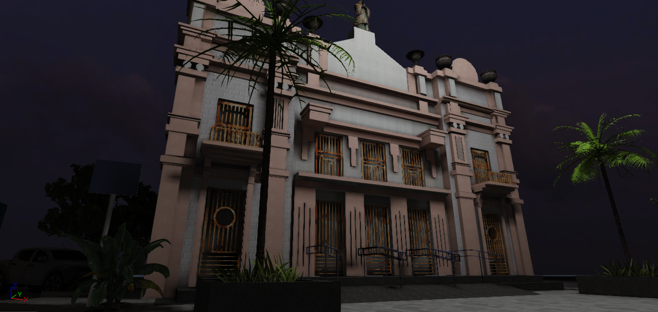
3D digital model of a historic building with a pink and gray facade, barred windows, palm trees and a night sky

Abstract

This applied research aimed to investigate and develop an optimized process for creating three-dimensional digital scale models for audiovisual production, integrating 3D modeling techniques, process automation and methodological organization of production. The research was carried out through hands-on experimentation, iterative testing and a comparative analysis between traditional methods and the proposed method. The results point to a significant reduction in production time, greater standardization of digital assets and higher workflow efficiency, showing the potential of the solution for educational, cultural and audiovisual applications.

Introduction

The advance of digital technologies has significantly expanded the possibilities of visual creation and representation in the audiovisual field. However, traditional processes for developing sets, environments and three-dimensional structures still have limitations in production time, high cost and low scalability.

In this context, digital scale models emerge as a viable alternative for simulating spaces, narratives and complex environments. Yet the lack of standardized methodologies and automated workflows can compromise the efficiency of the creative process.

This research arises from the need to investigate and structure a more efficient method for producing digital scale models, integrating 3D modeling practices, asset organization and automation, with a focus on practical application in audiovisual projects.

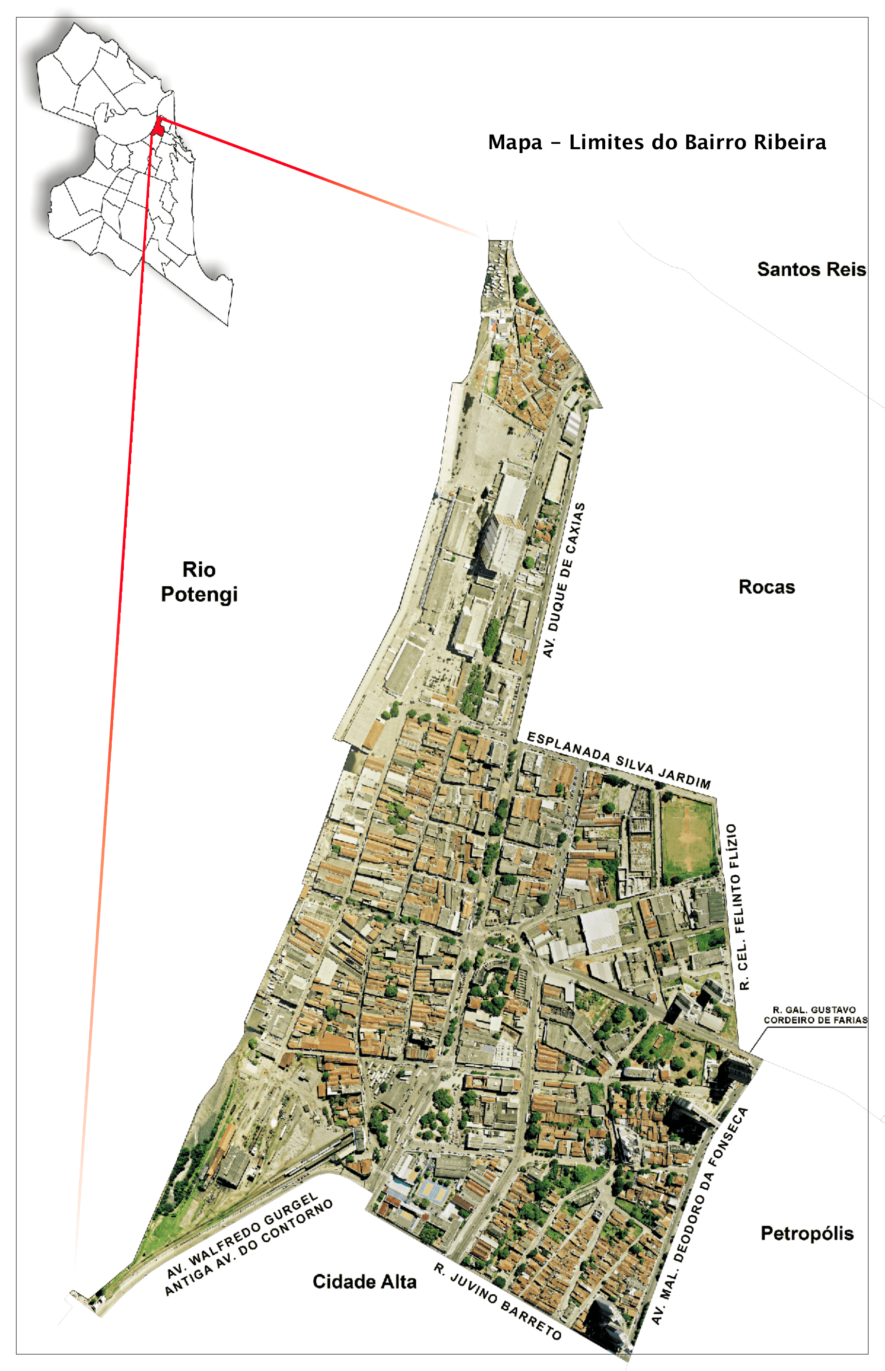
Location chosen for the research: the Ribeira neighborhood, in Natal/RN.

Map showing the boundaries of the Ribeira neighborhood in Natal, Brazil, over an aerial photo, surrounded by the Potengi River and the Santos Reis, Rocas, Petrópolis and Cidade Alta neighborhoods
Map — boundaries of the Ribeira neighborhood. Geographic data: SEMURB / DIPE / SPE, Natal City Hall.

Objectives

General objective

To develop and validate an optimized method for creating digital scale models applied to audiovisual production, aiming for greater efficiency, standardization and shorter development time.

To develop an automated procedure for creating 3D digital scale models used in animated shorts, mid-length and feature films, and video games.

Specific objectives

  • Investigate 3D modeling techniques and tools applicable to creating digital scale models.
  • Structure a replicable production workflow.
  • Test the automation of stages of the creative process.
  • Compare the proposed method with traditional production approaches.
  • Evaluate the time and organization gains obtained with the solution.
  • Speed up the creation of 3D digital scale models, cutting the time needed by up to 50%.
  • Develop a methodology that lets any design professional use this technique to reproduce real-world places.
  • Ensure accessibility and knowledge sharing through an open source platform.

Rationale

Contemporary audiovisual production demands agile, scalable and economically viable solutions. Adopting digital scale models allows greater creative control, lower costs compared to physical set design, and flexibility in adapting narratives.

From a scientific and technological standpoint, this research is justified by contributing to the development of an applied methodology that joins theory and practice, and by generating knowledge that can be replicated in educational, cultural and institutional contexts.

Methodology

The research was divided into stages, each carefully planned and carried out to ensure the precision and quality of the results.

Aerial and ground mapping

A DJI Spark drone with a 4K camera captured aerial images of the neighborhood’s streets, sidewalks and architectural details.

A GoPro 9, also 4K, filmed and photographed signs, facades and other important elements.

3D virtual sphere

The captured images were integrated into the inside of a 3D virtual sphere (Polycam), creating a rich, detailed environment on the computer.

Scale conversion

Measurements of physical elements, such as street width and building height, were converted into pixels and adapted to the software’s working scale, via an FBX file.

Automatic drawing with AI

Artificial intelligence algorithms processed the images and scale information, letting the tool draw the 3D model automatically with high fidelity to the real world.

Manual drawing

In the Unreal Development Kit (UDK) engine, the model of the study area was drawn by hand, vertex by vertex, to assess the time and effort involved.

Documentation and outreach

Every step was documented in a logbook, including difficulties, solutions and improvements.

Results and methods were published on a website dedicated to the research, with sign language (Libras) interpreter videos for accessibility.

Results

The research resulted in an automated technique that cuts the production time of digital scale models to 50% of the estimated time (for production with vertex drawing), without compromising quality.

200 hto draw the model manually, spread over 60 working days
30 husing photogrammetry, spread over 16 working days
500+aerial images captured
300+ground images captured
Important point. The biggest difficulty with photogrammetry is the need to film the place from different angles. This requires full access to the location and filming equipment.

Results in detail

Aerial and ground mapping

More than 500 aerial and 300 ground images ensured full coverage of the Ribeira neighborhood. The images were processed to remove distortion and improve visual quality.

3D virtual sphere

The images were integrated into a virtual sphere using Polycam, UDK and 3DS Max, allowing an immersive view of the mapped environment.

Scale conversion and automatic drawing

Physical measurements were converted precisely, and the AI was trained to recognize and draw architectural elements from the images and scale data. The result was a 3D model that faithfully replicated the neighborhood, including facade textures and traffic signs.

Manual drawing

Measurements were drawn by hand, without full precision, based on the available images and scale data. The resulting model represents the neighborhood with details such as facade textures and traffic signs, although it is not a fully faithful replica.

Documentation and outreach

The logbook recorded every stage, with methods, challenges and solutions. Results were published on the research website, with explanatory videos and sign language interpreters.
Inside the model

Images of the Ribeira neighborhood model built in the engine, in wireframe views and with textures and lighting.

Conclusion

The automated technique developed in this research is a significant step forward in producing 3D digital scale models, offering an efficient and precise tool for design professionals. The methodology not only speeds up the process but also democratizes access to advanced 3D modeling technologies, benefiting small producers and independent professionals.

The tool used for photogrammetry and for building the automated model was the Polycam software. Files were exported as .FBX, and can also be exported in the formats below, which are compatible with many content-creation engines for games and animated films, allowing them to be used in virtual environments and multimedia applications.

.FBX.OBJ.GLTF.DAE.STL.USDZPOINT CLOUD.PLY.LAS

Appendices

The results and the full step-by-step of the research are published with images and attachments, aiming for full accessibility.

  • Standardized image maps (Appendix I)
  • 3D virtual spheres with interior images (Appendix II)
  • Scale data used in the research (Appendix III)
  • Detailed research journal (Appendix IV)
  • Full research (Appendix V)
  • Logbook (Appendix VI)

Research open to collaboration

This project is open source. Any professional who feels able to update, improve or otherwise contribute to the development of the research is welcome to send their contribution.

The research remains open to future contributions, encouraging continued collaboration from the community.

Support and acknowledgements

Logos of the José Augusto Foundation, Natal City Hall, Política Nacional Aldir Blanc, Ministry of Culture and Federal Government of Brazil

This project was supported with funds from the Aldir Blanc Law 2, promoted by the José Augusto Foundation, Natal City Hall, the Ministry of Culture and the Federal Government of Brazil.

We thank the dedication and effort of the team involved and everyone who contributed to the success of this project, especially the José Augusto Foundation, Natal City Hall, the Ministry of Culture and the Federal Government.

Reference

Geographic data were collected from the Municipal Secretariat for the Environment and Urban Planning (SEMURB), through the Department of Information, Research and Statistics (DIPE), Research and Statistics Sector (SPE) of Natal City Hall.
